
Major Cities of Novegrad
For information on other cities not listed below, there is an Interactive Map available.
Click the maps below for an enlarged map.
Novegráde Velíkei
See Novegráde Velíkei.
Néugrade
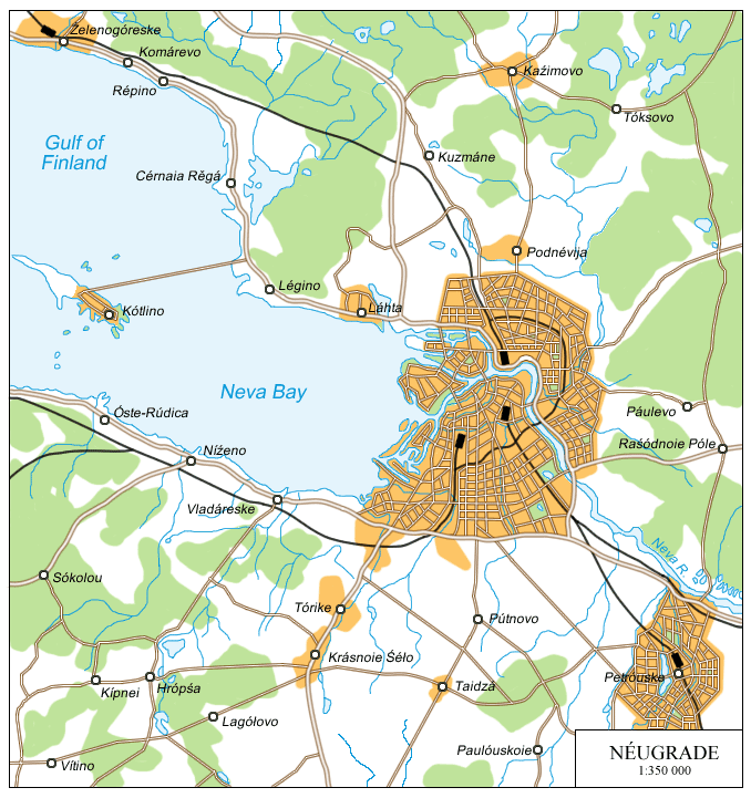
Néugrade is Novegrad's second-largest city, with a population of around 1,694,000. It is located at the mouth of the Nevá River, where it flows into the Gulf of Finland and the Baltic Sea.
Before 1720, much of Novegrad's history was marked by a series of wars with neighboring Sweden and a back-and-forth exchange of territory. In the First Northern War of 1656-1659, Novegrad under the leadership of Tsar Nikoláie I captured much of modern Latvia and parts of Estonia, as well as the territory of Ingria, roughly equivalent to the northern 2/3 of Neugradeskáia óblosti, between the Gulf of Finland and Lake Ládoga. In 1673, a large fort was constructed near the Swedish border, known as Aleksándre-Néuskei (named for the famous prince). Nearby, at modern Láhta, a small town arose focused on building vessels for the new Baltic Fleet. In the Great Northern War (1700-1717), the fort was the site of much fighting, and although the town was ruined, the fort never fell. The fort was also the staging point for the famous Stockholm Assault (1717), during which much of the Swedish capital was burnt down. At the conclusion of the war, Novegrad gained control of Finland and the fort's importance steadily began to decline, as it was now well within Novegradian lands. The surviving citizens who had taken refuge in the fort began the reconstruction of their settlements, leading to the foundation of Néugrade in 1717, slightly to the southeast of the earlier settlement. Although originally a small fishing settlement, Tsar Mécislau had it become Novegrad's new primary port city and the center of the new Baltic Fleet. Now established as the foremost Baltic power, the city's population expanded rapidly as it joined the ranks of Europe's largest ports.
In 1917, the Red Revolution began in the Empire of Russia and Novegrad. With the proclamation of the Soviet Union, the personal union between the two nations was dissolved and Novegrad returned to independence, albeit with a weak monarch, Tsar Veiódore IV, who had fled from Russia. The Novegradian Communist Movement was based in Néugrade, and in 1925 deposed the tsar. It briefly became the capital of the Soviet Republic of Novegrad to distance itself from the former tsarist regime of Novegráde Velíkei, but it was moved back within two years. Under the communist government Néugrade was heavily industrialized. As the Thaw of the 1970s began, the city became the gateway to the West, and was the first city to begin to see foreign investment. This growth in the fields of business and trade took off in 1991 with the collapse of Soviet power in Russia and the Signing Over of Novegrad. It is now a center of business, as well as the electronics and automotive industries, including such automobile manufacturers as Novauto, BMW, and Ford.
Due to its location on the Baltic Sea, Néugrade has a relatively mild (though very unpredictable) climate. Winters are long and cold, averaging around -7˚C in January. The Nevá is generally frozen about four to five months out of the year. Average July temperatures are around 25˚C, humid, and prone to sudden rains. Springtime flooding is not uncommon, and this is part of the reason for the construction of the Kótlino Dam across the Nevá Bay.
Néugrade is a regional transportation hub. It is the meeting place of the primary highways from Novegráde Velíkei, the Baltic States, eastern Novegrad, and Finland. It has three major railway stations serving different directions. Its port has access to the ocean via the Baltic Sea, but is also the western terminus of several canal systems—the Baltic-White Sea waterway which leads toward the Arctic Ocean, and the Volga-Baltic waterway that passes through Russia toward the Black Sea. The city is also served by two major airports.
Due to its location on a river delta, the city is crisscrossed by waterways and consists of a number of islands, which form the boundaries of the city's municipalities (or "raióni"). The historical and governmental centers are located on the series of long, narrow islands on the left bank of the Nevá, in the heart of the city. To the south is the large Velíkei Óstrove, home to the primary business district, the Néugrade State University and the Néugrade Institute of Technology, and the Vostócnaia Railroad Station. The north-central sections of the island are home to the city's most expensive luxury apartments, rowhouses, and hotels. The southwest mainland portion of the city is largely industrial, particularly around the port district. The southeast is largely mixed-use, mostly business, commercial, and residential land.
The northern side of the city is mostly residential and commercial, with more expensive housing closer to the river. The three large islands in the middle of the Neva delta form the cultural center, home to the grand Nikoláieuskei Theatre, the Great Novegrad Library, the Baltic Arena, numerous museums, and several large parks. The central island, most commonly called Stároie (the "Old Island"), officially Óstrove Morácei ("Seaman's Island", from its original use), is considered the center of Néugrade's nightlife.
Pleskóve
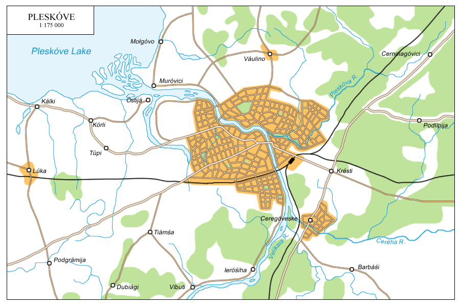
Pleskóve is one of Novegrad's oldest cities, dating from 903 AD. The present population is around 511,000. The city is located at the confluence of the Velíkaia and Pleskóva Rivers, near where they flow into the Pleskóve Lake.
The first mention of the city comes from 903 AD, generally considered to be the city's founding date. The city was part of the Novegradian Feudal Republic until 1241, when it was captured by the Teutonic Order, but was then liberated several months later by Prince Aleksándre Néuskei in the Battle of the Ice. Under the rule of Prince Daumónte, Pleskóve gradually became an independent principality, recognized by Novegrad by 1348 (although effective since the mid 1200s). The Pleskóve Feudal Republic became a major trading center, and merchants later brought the city into the Hanseatic League. Due to its strategic location, the city became the target of at least 30 sieges through its history. The city became the most heavily fortified in the region, at its height having five stone walls surrounding it. It never fell until it was captured by Novegradian forces in 1489. It continued to function as a major border fortress until the First Northern War expanded Novegrad's borders in Estonia, and Pleskóve found itself over 150km within Novegrad, where it had previously been only 30. While its military function began to decrease, its importance as a trading center continued to grow, and soon it became both an industrial center and an administrative center for many of these new territories.
In the Red Revolution, Pleskóve quickly came under communist control. In the 1930s a large military base was established to the north of the city. In the Second World War Pleskóve quickly fell to the Germans, its stone walls being no match for modern artillery. It was liberated in February of 1944, but had suffered significant damage. The city was largely restored through the 1950s and 1960s, and became a leading aeronautics center, largely for the Novegradian airforce. As the Thaw got under way, this expanded into the private and commercial sectors as well.
Pleskóve has a continental climate. Average January temperatures are around -7˚C, and average July temperatures around 17˚C. Winters are generally long and summers humid.
Pleskóve still holds its former status as the gateway between Novegrad and the Baltic republics. It is a regional highway and railroad hub, connecting south and west to north and east. The Velíkaia River empties into the Pleskóve and Estonian Lakes, linking Pleskóve with a number of other nearby cities, the largest of which is Iúriéve (Tartu) in Estonia. The Nárova River, which connects Estonian Lake with the Gulf of Finland, allows access to the Baltic Sea and open ocean. The distance from Pleskóve to the Gulf of Finland totals about 230km. It is served by Pleskóve International Airport.
At the very heart of the city is the Pleskóve kremlin, the original citadel protecting the city. Around the kremlin are a number of historical churches and other buildings, forming the city's historical district. Parts of three of the original walls survive. Inside the innermost wall is the kremlin. Within the second wall are mostly older buildings and houses. Within the outer wall more modern buildings are found, including restaurants, office buildings, and schools. Modern Pleskóve is known for the rather unusual sight of modern highrises standing right next to medieval stone walls. The largest industries in the city are aerospace and electronics, most of the facilities of which can be found in the western parts of the city.
Vóloğda
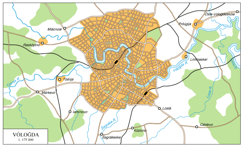
Vóloğda is the largest city in central Novegrad, with a population of around 1,203,000. It is located on the Vóloğda River, a tributary of the Suğóna and Northern Duiná Rivers.
The early history of the city is scarce. The first mention of the settlement dates from 1147. In 1273 the city was attacked and largely destroyed by the Mongols. With the resurgence of Novegradian power in the region beginning around 1490, the city slowly began to grow. After Arhánjeiske was founded in 1530, Vóloğda became a major trade center in central Novegrad, acting as a distribution center for goods going to or coming from Arhánjeiske via the Northern Duiná and Suğóna Rivers. In 1566 it became the administrative center for all of the eastern territories excluding Arhánjeiske. After the Great Northern War secured Novegradian access to the Baltic Sea, the importance of the city as a center of trade rapidly diminished, but the city survived economically because of its administrative functions. In the 19th century, Vóloğda once again experienced rapid economic growth as it was connected to the west by railroad and numerous industries sprang up in and around it.
In the 20th century, under the communist government, Vóloğda became the center of trade between the eastern and western portions of the country. During the Second World War, many military facilities relocated to Vóloğda from regions that had been overrun by the Germans or were deemed too close to the front lines. Since then, Vóloğda has been Novegrad's leading aerospace research and development center. The primary cosmonaut training center is located 50km northeast of Vóloğda. Most rockets built in Vóloğda are launched from the Pleśéteske Cosmodrome in the far southern part of Arhangeleskáia Óblosti, or from the Sahalíneskei Kosmodrome on Sahalíne Island in the Pacific (territory leased indefinitely from Russia).
Vóloğda has a continental climate typical of much of the Novegradian interior. Winters are long and cold (January temperatures averaging -13˚C). Summers are shorter, but warm (July temperatures averaging 18˚C). Weather conditions are known to change frequently and suddenly.
Vóloğda is a major transportation hub between east and west. The area around the city is crossed by roads and railroads leading in all directions. Virtually any part of the country can be accessed by river. The Vóloğda River flows into the Suğóna and then the Northern Duiná, which empties into the Arctic Ocean at Arhánjeiske. Going upstream the Suğóna instead leads to the Kubeneskóie Lake, which is linked to the Śehná River by canal, a part of the Volga-Baltic Waterway. Two airports also serve the city. The Pleśéteske Cosmodrome may be reached by railroad, while most materials being shipped to Sahalíneskei Cosmodrome must pass through Russia on the Trans-Siberian Railroad.
The oldest part of Vóloğda is located in the south-central region, on the right bank of the Vóloğda River. The southern half of the city is the commercial and business district, with some expensive housing and hotels by the river. The most modern district of the city is located between the two main southwestward conduits out of the city, Leníneskei Prospéhte and Ólika Rośzíjskaia; oddly enough, this region also includes part of the historical district in the north. This district, the New City (Nóvei Gorodóke), is known for its skyscrapers, world-class entertainment establishments, and luxury hotels, and is also iconically the center of Novegrad's film industry. The northern half of the city is largely residential and industrial. The south-eastern district, along the river, is known for its restaurants and nightlife. In addition to being the primary manufacturing center for the Novegradian Space Agency, Vóloğda is also home to several commercial airplane manufacturers.
Arhánjeiske
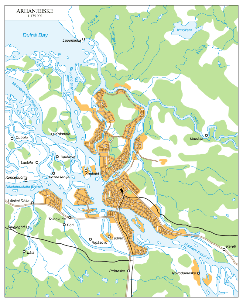
Arhánjeiske is Novegrad's largest northern city, with a population of 417,000. It is located at the mouth of the Northern Duiná River, on the White Sea.
The site of modern Arhánjeiske is believed to have been settled before 1000, although by whom is not entirely clear. In the 12th century, the Archangel Michael Monastery was established by Novegradians in the Northern Duiná delta. In 1419, during the Novegradian-Norwegian War, the Norwegians plundered the monastery and a number of other settlements on the White Sea before being driven back. In 1530 the Arhánjeiske fort was established near the delta, named after the monastery. In the 1550s European exploratory ships began to enter the White Sea, primarily from England, Scotland, and Holland. The settlement around the fort was enlarged and a port built to allow for trade with these nations, and Arhánjeiske quickly eclipsed the town of Holmogóri further upstream, formerly the largest regional city. Arhánjeiske became the primary Novegradian port, as at the time Novegrad lacked any coastline in the Baltic, and even after it had gained some territory, it was under constant threat of attacks until the conclusion of the Great Northern War, breaking Sweden's dominance in the Baltic Sea and giving Novegradian ships full rights. For the Northern Wars, Arhánjeiske and nearby Śěveromorijá were the primary shipyards building military vessels. Despite the fact that the sea was frozen over five months out of the year, the city grew as a major commercial center. After the founding of Néugrade, destined to become the primary port, Arhánjeiske began to decline in importance due to its distance from Novegráde Velíkei and other major cities and its lack of an ice-free port.
In the Red Revolution, Arhánjeiske remained an anti-communist stronghold in support of the Tsar. In the two World Wars the port was revived somewhat as it became the main port for bringing in and shipping out supplies once the Baltic was no longer safe. After World War II the city began to grow once again as local industry was encouraged, and with the development of a nuclear-powered icebreaker in 1955 the port once again became a major commercial and business center, now that it could be used all year round. In 1995 the first reversable icebreakers in the world were introduced, further improving the port. These reversable icebreakers have a normal front hull, allowing easy and smooth movement, but an icebreaker-styled stern, so that when moving through ice the ships actually travel backwards. Arhánjeiske is now a major center of trade and manufacturing.
Arhánjeiske has a subarctic climate, although this is moderated by the maritime environment. Winters are long and cold, January temperatures averaging around -13˚C (but significantly warmer than cities slightly further inland, away from the White Sea). Summers are generally short and warm, with July temperatures averaging around 17˚C.
Arhánjeiske is in many ways the capital of the Novegradian North. It and nearby Śěveromorijá are by far the largest cities in the area, and are major transportion hubs. Roads generally only lead west into Karelia and south into central Novegrad, however, because most of the vast territory to the immediate east of the city is very sparsely inhabited and largely forested. On the other hand, it does have major rail links to the east (although the railroads take a dip to the south first), primarily for the transport of resources from the trans-Ural provinces. The port provides access to the open seas, or deep into the Novegradian interior by travelling upriver. The city is served by a single airport.
Due to its location, the city of Arhánjeiske consists of a number of islands. The center of the city is located on the Main Island (Gláunei Óstrove). Here are the city and oblost administration, churches, museums, several schools and colleges, the railway station and the main port. No building on this island is higher than 15 stories. To the north is the Lower Island (Níźnei Óstrove). The southern part of Níźnei Óstrove is dense city, with numerous skyscrapers and the business center of the city. The rest of the island is somewhat less organized, with scattered development along the coasts, although the developments are growing. These are mostly industrial in the northwest of the island, and residential/commercial elsewhere. To its west lies Bogáčei Óstrove, from an Old Novegradian root meaning "wealthy". This area was once inhabited mainly by wealthy foreign merchants, and it remains the site of expensive houses and fine dining. The community of Tálagi, located on the mainland but only reachable from Gláunei Óstrove, is a middle-class housing development, consisting of regular housing instead of apartment blocks. The same can be said of Kegostróve Island and Cigloméni, the two westernmost communities. Opposite Gláunei Óstrove, on the opposite side of the Northern Duiná, is Bakaríca Island, similar to Níźnei Óstrove in its focus on business, commerce, and industry. These islands are connected to each other by a number of bridges. Other islands may be reached by boat, and their largely untouched wilderness is a major tourist attraction in the summer months.
Víborge
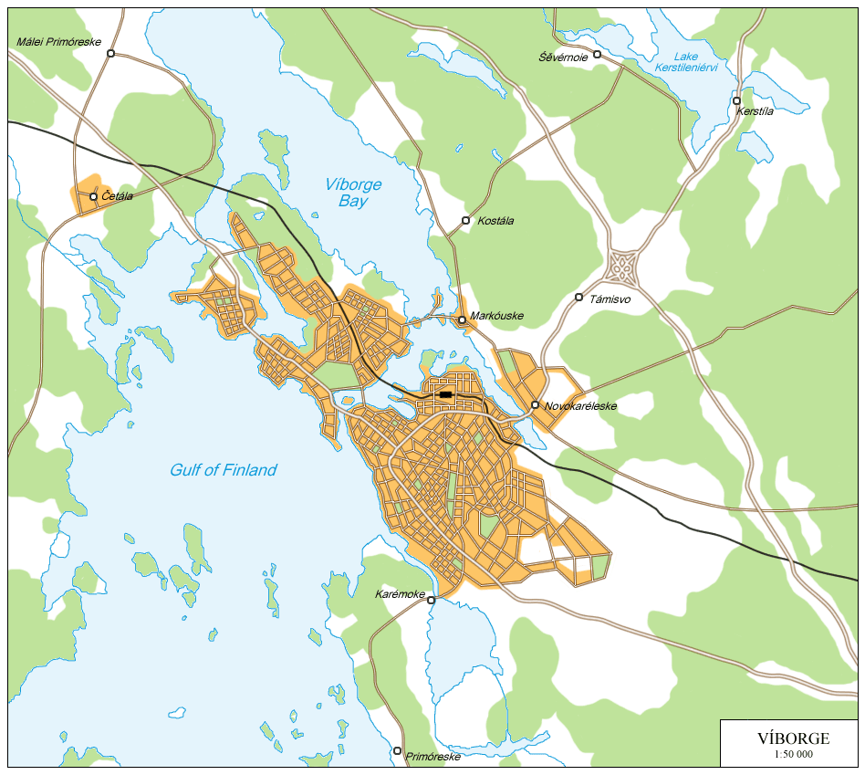
Víborge, while not as large as many other Novegradian cities, is nevertheless a significant port and historically a strategic location long sought after by both Sweden and Novegrad. It is located near the head of the Finnish Bay and has a population of 98,000.
The first castle was built by Sweden at the site of modern Víborge in 1293, during a period in which both Sweden and Novegrad were rapidly expanding into the area of modern Finland. The territory was fought over until the Treaty of Orěśeke/Nöteborg (1323) for the first time defined a border in the region between Novegrad and Sweden, and Víborge came under Swedish control. The fortified town was the target of a number of attacks during the Novegradian-Swedish Wars, and was never captured until the Great Northern War, when the Treaty of Níśtadte/Nystad granted Novegradian sovereignty to Swedish Finland. In 1815 the city was transferred from Finland to the Neugradeskáia óblosti, largely for political reasons, where it has remained. Over the course of the 19th century the city grew as a center of trade, especially after the Saiméneskei Canal was built, connecting Lake Saimaa and other lakes in the Finnish interior to the Gulf of Finland. In World War II the city was evacuated and heavily damaged by sea and air attacks, but was rebuilt afterwards. It has since developed a modest machinery industry, although paper is still the primary production industry.
Víborge has a climate very much like that of Néugrade, with mild winters (January average -7˚C) and warm summers (July average 23˚C).
Víborge is less a transportation hub than a major waystation along many routes. The largest east-west roads and railroads between Néugrade and Finland pass through or near Víborge, and the southern terminus of the Saiméneskei Canal is at the north tip of the Bay of Víborge. Víborge city is served by a single regional airport.
Víborge is the largest bilingual city in Novegrad not in one of the republics. Both Finnish and Novegradian are widely used, and it is not unusual to hear speakers switch back and forth between them several times over the course of a conversation. Most of the city is located on the Víborge peninsula jutting out into the bay, but it also consists of two large islands and several smaller ones. The oldest part of the city is located at the northwestern end of the Víborge peninsula, and the old Víborge Castle built by the Swedes still stands on a small island just offshore. The rest of the peninsula contains the primary commercial district and the industrial facilities in the south. The largest island, Tuerdíśe, is an extension of the commercial district, but also includes the large Párke Vitéźestwu. Also located here is the 'Lenin House', where Lenin first proposed the April Theses in 1917. In the northern end of this island, development has only begun recently, and many houses are being built. Just east of Tuerdíśe are three small islands, commonly called the Tróika, which house several luxury estates. Just west of Tuerdíśe is Málei Óstrove ('the Small Island'), the newest to undergo urbanization, and a large commercial district home to the Víborge Shopping Mall.
Turaúle
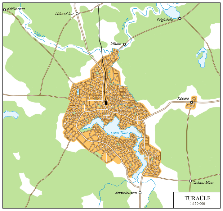
Turaúle is the largest Novegradian city east of the Ural Mountains. It is located high up the Túra River and surrounds Túra Lake, in the foothills of the mountains. It has a population of 409,000.
The city was founded in 1699, when a large iron foundry was built to serve a nearby quarry. Due to its relative isolation, the city was largely self-sustained for much of its early history, but the land around the city was very rich in mineral resources. When the first railroad was built in the 19th century connecting it to Vóloğda (using iron produced by this very same foundry), the city population began to rise exponentially. Other mining facilities were established to extract other valuable metals from the mountains, and the standard of living improved dramatically. In the late 1800s, oil was discovered. During the Red Revolution, it and several other wealthy Siberian cities remained Tsarist strongholds up until the tsar was deposed. In the mid 1980s the service sector of the economy began to grow significantly along the industrial, and began the process of cleaning up and repairing some of the older factories and polluting mines. Although pollution is still a major problem, in recent years with stricter regulations the situation has been improving.
Turaúle has a continental climate, with a large range of temperatures due to the Ural Mountains. Winters are long and cold, with snow cover generally lasting from November to April. The average January temperature is -16˚C, and the average July temperature is 18˚C.
Turaúle is a rail terminus, and is directly connected to Cernográde to the north and Śibíreske to the east. There are talks of extending the railroad southward to the Russian city of Yekaterinburg, but no decision has yet been reached, although a highway already connects the two. The Túra River is navigable downstream, although it passes through Russian territory before returning into Novegrad, but agreements between the two nations allow relatively free access to the river. The Túra is not navigable by large ships any further upstream than the Túra Lake. The city is served by Turíneskei Airport to the east.
The city streets have a very confusing layout from the perspective of non-natives, largely because the early development of the city lacked much oversight and developed organically and roads were often constructed after the region had already been built up. The oldest part of the city is in on the northern shore of the Túra Lake. The industrial center of the city is found in the northeast, while the newer business center is in the northwest. The relatively new areas on the south side of the lake are largely residential and include most of the schools, theatres, and other entertainment establishments. Most mines are located to the west of the city, higher in the Urals. Ores are returned to Turaúle to be processed, smelted, and then transported to the rest of the country, primarily by rail. Most oil, on the other hand, that comes from the oil fields out east isn't processed or refined in Turaúle, but instead is sent out to Súrgute or Arhánjeiske.
Revéle
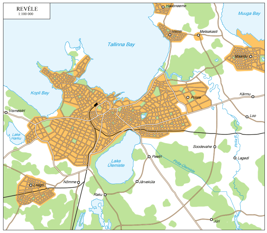
Revéle is the capital city of the Estonian Republic, located on the Gulf of Finland. It is by far the republic's largest city, with a population of 502,000. In Estonian it is known as Tallinn (Таллинн).
The first record of the city of Revéle comes from 1154, when it was mentioned on Arab maps. It came under Danish rule in 1219 and was forcibly Christianized. In 1285 the city joined the Hanseatic League, and in 1345 was sold to the Teutonic Order. The city thrived as a strategic center of trade between Europe and the Russian Principalities and Novegrad. In 1561 it came under Swedish control. The region of Northern Estonia, including Revéle, became a focal point of several of the Novegradian-Swedish conflicts of the 16th through 18th centuries, and changed hands several times. After the First Northern War, the eastern half of Revéle was annexed by Novegrad, but the proximity of it to the Swedish Western Revéle (the capital of Swedish Estonia) virtually caused both halves to become military cities. The entire city, along with all of Estonia, was handed over to Novegrad after the Great Northern War. In the mid-18th century a fairly intensive period Novegradization began, although the Estonian language remained in common use, albeit using Cyrillic script. In the 19th and 20th centuries, Revéle became a major, modern port.
In 1917, when Russia-Novegrad split apart and the Red Revolution was blazing across both countries, Estonia declared its independence with Revéle, now renamed Tallinna, as its capital. However, Estonia and the rest of the Baltic was overrun by the Germans after the Russians refused to sign an armistice, as they did not yet recognize the separation of Russia and Novegrad. After Germany's defeat, the Treaty of Versailles which redrew Germany's borders assigned Estonia and Latvia to Novegrad, effectively ending their brief independence. Tallinna's name was returned to Revéle, and it became the capital of the Estonian Soviet Socialist Republic within Novegrad. During World War II it was again occupied by the Germans, and was liberated in September 1944. Starting in the late 1980s, Revéle became a major center of the computer industry in Novegrad, which it remains to this day, as well as the nation's second largest automotive center (after Néugrade).
Revéle has a temperate and somewhat humid climate due to the Baltic Sea. Winters are long and cool (average January temperature -5˚C), and summers mild (average July temperature 17˚C). Spring and winter are generally rather wet.
Revéle is Estonia's transportation hub. The road and rail networks link up most of the republic with Novegrad. Large ports in Tallinna and Muugla Bays handle large amounts of goods and people annually. Tallinn Airport handles most of the city's domestic flights.
The oldest part of the city is Toompea Hill, located in the center of the modern city and is surrounded by a small ring road. Originally a castle, the walls have been rebuilt many times according to the styles of its owners. Inside the present-day walls are the Estonian government, several Lutheran and Orthodox Churches, and the Estonian Academy of the Sciences. The Old City of Revéle surrounds Toompea, largely to the north of Lake Ülemiste. Many buildings in this area display a very traditional Estonian architecture, and are home to numerous businesses, restaurants, stores, schools, and homes. The Eastern and Western Cities were largely built up during the Soviet period and are largely residential and commercial, but also include most of the city's centers of higher education. The area west of Lake Ülemiste is known as the New City, which has been expanded rapidly since the 1980s as a center of business, both dometic and international. The north and western parts of the New City are dominated by skyscrapers, while the south is largely industrial.
Ríga
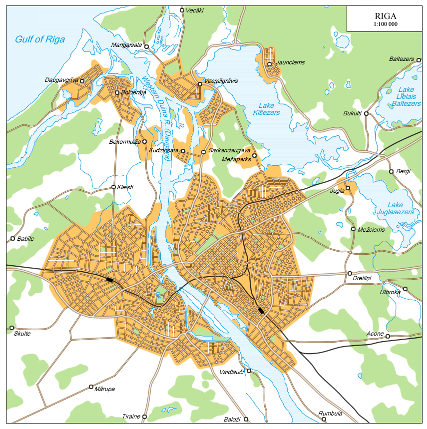
Ríga is the capital city of the Latvian Republic, located on the Western Duiná (or Daugáva) River. It is the largest city and port in the two Baltic republics, with a population of 929,000. In Latvian it is known as Rīga (Рӣга).
Ríga was founded by German missionaries and merchants in the 12th century, eager for new land and to convert the local population, and later came under Teutonic control. It grew as a center of trade between Baltic peoples and the Russian principalities and Novegrad to the east, and in 1282 joined the Hanseatic League. As the Hanseatic League began to decline in the 16th century as the result of other alliances formed by members, Ríga became an object of desire for several foreign powers. Teutonic power fell in 1561, leaving the city independent for twenty years before it was annexed by Poland-Lithuania in 1581. Ríga and Livonia later fell to Sweden, and then to Novegrad after the First Northern War.
Like Estonia, Latvia declared its independence in 1917 from both Novegrad and Russia. However, soon afterwards it was overrun by Germans and in 1919 returned to Novegrad by the Treaty of Versailles. The Latvian Soviet Socialist Republic was unruly for much of the time between 1920 and 1980. In the Second World War it was again invaded by Germany, and liberated in November of 1944. In the late 1970s tensions in Latvia began to cool when Śérgeie Aleksándrovice Rubínine, whose mother was Latvian, became premier and initiated the Novegradian Thaw. The modern city is a major center of trade and commerce, as well as a center of the computer and electronics industries.
Ríga has a temperate and humid climate largely moderated by the Baltic Sea. Winters are long and mild (average January temperature -2˚C) and summers short and mild (average July temperature 18˚C).
As a major port city, Ríga has become a major transport hub, not just for Latvia, but for much of extreme southwest Novegrad. Much of the Western Duiná River within Ríga is lined by piers for ships to dock, and many additional docks are located in nearby Lake Ķīšezers. The city is also the center of Latvia's road and rail network, and is one of the termini for Novegrad's highspeed rail. It is served by Ríga International Airport.
Ríga is generally divided into two portions, the Right Bank and the Left Bank. The Right Bank, the northern half of the city, is the older portion. Ríga Castle, the location of the Latvian government, is located on the riverbank. This half of the city is very urban, with numerous small streets and tall buildings. The northern region is a large commercial district home to several large department stores, recreation centers, shopping centers, and parks. Ríga State University, one of four major universities in the city, is located at the end of the large Millenium Park, the city's largest. The left bank, on the other hand, is famous for its green streets lined by trees and numerous small parks. Much of the city's most valuable real estate is located here, and it is the fastest-growing region, although this is slowly changing as Soviet-era apartment blocks on the right bank are being replaced by modern, clean apartment buildings and hotels.
Tórge
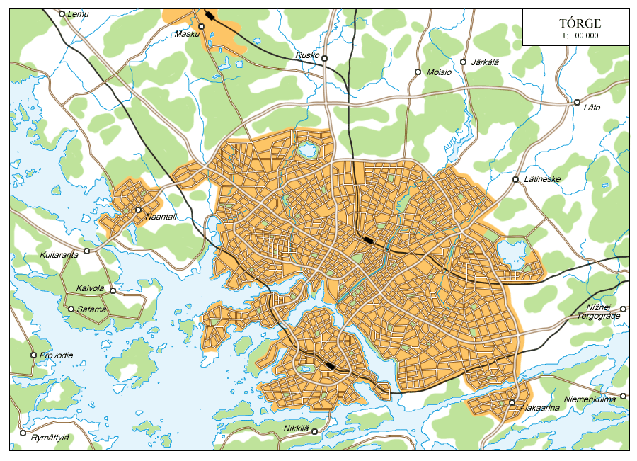
Torge (properly pronounced [tor-ge], not [tordž]) is the capital of the Finnish Republic. It is the largest non-Novegradian-majority city in the nation, with a population of 1,012,000. In Finnish, it is known as Turku (Турку).
Tórge is Finland's oldest city. When it was founded is not known exactly, but the city only became significant in the 13th century. Turku Castle dates from the 1280s. In the Middle Ages the city traded with the Hanseatic League and prospered, becoming Finland's de facto capital within Sweden. In 1717, at the conclusion of the Great Northern War, Finland was ceded to Novegrad, and Torge was developed as a major port city.
In 1917, independence movements sprang up across the republic, but rebellions in the three largest cities, Tórge, Něsijáreske, and Iélsinki, were quickly crushed by the Novegradian Royal Guard in Tórge and by Red forces elsewhere, and the territory forcibly held by the tsar until he was unseated. After the First World War came to an end, the territory became the Finnish Soviet Socialist Republic. While no actual fighting occured in the republic in the Second World War, Tórge functioned as the primary base for the Baltic Fleet while other ports were under German control or at risk of it. In the 1950s and 1960s the swampland throughout the city was drained completely, leaving the soil more stable for large-scale construction. The modern city is one of Novegrad's largest, and is home to thriving industries specializing in electronics, machinery, aerospace, and computers.
Tórge has a hemiboreal climate influenced by the nearby Baltic Sea. Winters are long and cool (average January temperature -6˚C) with frequent snowfall, and summers mild (average July temperature 17˚C).
Tórge has a complex road and rail network and connections to nearby cities. The city itself includes two large islands, and neighboring towns are located on many other islands connected by a series of bridges. The city has access to the Baltic Sea once past all of the islands of the Archipelago Sea. Two large airports serve the region.
The oldest part of the city is located on the mainland, around the mouth of the Áura River. The city center is very dense, with high skyscrapers functioning as centers of business, apartments, hotels, stores, restaurants, and often combinations of the above. Outside of the center Tórge is much more sprawling. Several of Finland's most prestigious universities, including the Royal Academy of Turku and the Tórge School of Economics, are located around the city center. The two islands, like much of the mainland city, consists of smaller towns that were absorbed by the rapidly-growing city. Tórge is effectively a trilingual city, due to a large minority Swedish population located in several, generally more higher-class neighborhoods.
Iěneslina
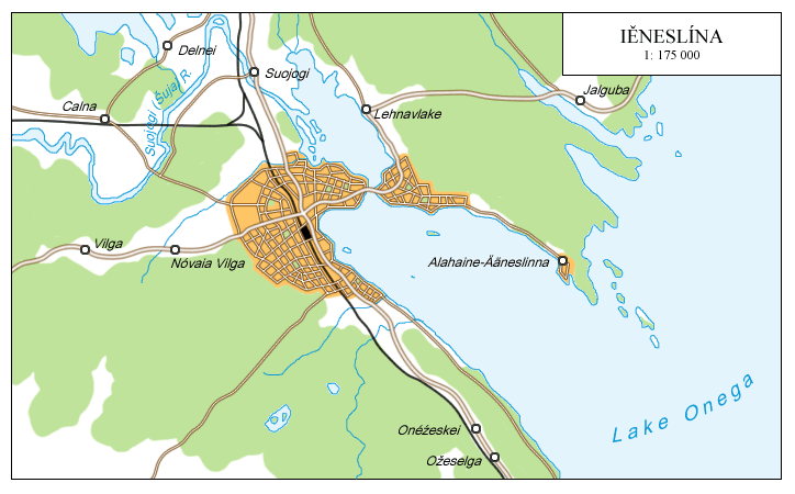
Iěneslina (pronounced [i-ne-sli-na])is the capital of the Karelian Republic. It is the republic's largest city, with a population of 128,000. In Karelian it is called Ääneslinna (Ѣѣнеслинна).
Iěneslina was founded in 1688, making it one of the newer republic capitals. It started as a small fishing village, dwarfed by the nearby regional centers of Olonéce and Kondopóğa (in Karelian, Aunus and Kontupohiu). However, in the 18th century, a number of foundries were established in and around the city, the largest of which was the Néuskei Ironworks. The city began to expand as a center of iron production, and its port was expanded to accomodate large ships. In the early 19th century, the Kola Railroad, which travelled the length of Karelia up into the Kola peninsula, was built through the city, further encouraging its growth and increasing the city's supplies of raw metals. It soon surpassed Olonéce, becoming the new economic center of Karelia. However, Karelia on the whole has remained largely underdeveloped, and Iěneslina is still very small compared to the capitals of the other republics. Karelia has been working hard toward encouraging investment, and in recent years has seen some of the nation's most rapid economic development, largely due to the region's natural resources.
Iěneslina lies in between the maritime and continental climatic zones. Winters are long and cold (January average -10˚C) and summers short and mild (July average 15˚C).
Iěneslina is not generally considered a transportation center, largely because of the underdevelopment in the region. Roads and rails in the region connect north, south, and west, and there are discussions of expanding the road network around the city as it continues to grow. The city has direct access to Lake Onéga and the Baltic-White Sea waterway, allowing the city to transport many finished products itself. It is served by West Onéga Regional Airport.
Much of Iěneslina is still dominated by residential districts and local businesses in the downtown. Iěneslina University, located on the shores of the lake, is the center of Karelian studies and the Karelian Language Academy. In the western outskirts of the city are the major foundries and other metal processing and refining centers. Much of the eastern coast of the Iěneslina Inlet is being developed as new roads, homes, and stores are being built, especially near the southern end around the new town of Alahaine-Ääneslinna (Lower Iěneslina).
Sihtikáre
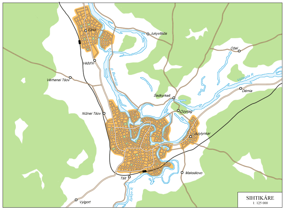
Sihtikáre, known in Komi as Syktyvkar (Сыктывкар), is the capital of the Komi Republic, located at the confluence of the Syktyv/Syzóla and Výčegda Rivers. It has a population of 258,000.
A settlement at Sihtikáre is known to exist since at least the 16th century, then known as Óstie-Syzóleske (Mouth of the Syzóla). It grew significantly during the 18th century, when it became a major transport center between the growing Siberian east and the old west. The Komi population of the city rapidly increased as the promise of wealth drew in many people. In 1922 Óstie-Syzóleske became the capital of the new Komi Republic, and was renamed Sihtikáre in 1929, Komi for "City on the Syzóla". Within the republic the use of Komi was greatly encouraged, and to date 84% of the population speaks the local language, more than in any other republic. In two separate periods, the 1930s and later the 1970s, many cities across the republic were renamed and given Komi names. Sihtikáre has seen a recent boom in the aerospace, plastics, and machinery industries, encouraging growth in the city.
Sihtikáre has a mildly continental climate, with long, severe winters (average January temperature -15˚C) and short, mild summers (average July temperatures 17˚C). The city's roads and rails connect to several nearby cities, making it a local transportation center. Major roads and the railroads generally hug the rivers, however, and most cities in the region are located on or near a river. Although the Výčegda is navigable in Sihtikáre, most transportation of goods is done by train rather than ship. The three largest local cities, Síhtikare, Iujilynkáre, and Iéźva, are served by Sihtikáre Airport, often called Kuimkarsa Airport (Komi for 'Three Cities') for that reason.Sihtikáre is spread over several islands, connected to one another by 11 bridges. Development on the islands is relatively recent, coming as the result of recent growth. The islands are generally home to residential and commercial areas. The business and industrial centers of the city are all located in the main part of the city, to the west of the Syzóla and Výčegda Rivers. Komi is the dominant language of the city, although knowledge of Novegradian is universal. Outside Sihtikáre, and even within it, traditional Komi culture is largely preserved, although nomadism has given was to a sedentary lifestyle. The forests near Ozyriáge and Sedkyrkéśe are known for a very wide variety of mushrooms used in traditional Komi cuisine.
For information on other cities not listed below, there is an Interactive Map available.