
Divisions and Neighborhoods
Present Arrangement
Novegráde Velíkei has three levels of divisions, serving both administrative functions and more common use for identifying locations.
The oldest division is between the two sides of the city as split by the Vołhóve River. The left bank of the river is known as Sověiskaia Straná or the "Sophia Side", named for the Church of Saint Sophia, the city's most famous landmark and a symbol of the Novegradian nation. The right bank of the river is known as Torgóvaia Straná or the "Market Side", named for the many markets once present along the river, filled with merchants from across the known world. These historical divisions no longer serve any real administrative function, although the terms are still used to refer to the collective ends (see below) that make up each side.
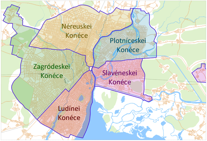
The next division, and the most important, is the division of the city into five kónci, or "ends". Nowadays they function as boroughs, each with an elected mayor and council responsible for local issues. They are also the primary means of identifying locations in the city; when asking what part of the city someone lives or where a particular building is, the most common reply will be the kónce. Most individuals and businesses within the city will use the end in their postal address rather than the city "Novegráde Velíkei". The five ends fit neatly inside the two sides. Sověiskaia Straná is subdivided into three ends, from north to south: Néreuskei Kónce, Zagródeskei Kónce, and Ludínei Kónce. Torgóvaia Straná is divided into two ends: Plotníceskei Kónce in the north and Slavéneskei Kónce in the south. The five ends all meet at the Krémene in the center of the city, which is technically not part of any of the ends.
Each end is then divided into a number of neighborhoods. They have no legal function beyond serving as census areas and for further specifying something's location within the end.
History
The two sides of the city are geographically separated, and some sort of distinction of the sort has almost certainly existed from the very beginning of the city. The modern names, however, probably date from the 11th or 12th century, once the city had developed its own complex administrative structure.
The end system is ancient, predating the known history of the city and connected with its early development. What would become Novegráde Velíkei in the 9th century originated as three separate but allied trading settlements, known as Slavno, Nerev, and Ludin. At their center was a fortified citadel, the Krémene, which was "Novegráde" (i.e., the "new city") proper. When these three settlements unified they retained a degree of autonomy, and formed the first threee ends: Slavéneskei, Néreuskei, and Ludínei. Plotníceskei was created in 1168 and Zagródeskei in 1264, completing the five ends that are still present today.
However, in Old Novegráde each end had a much greater function than they do in the modern city. The city was governed by a central Veche believed to have largely been dominated by the boyars, but each end developed its own urban administration as well. These originated as informal assemblies along individual streets, with the eldest man on each street generally serving as that street's leader of assembly. Conflicts and issues on that street would be handled by a democratic vote by all those living on the street, regardless of their wealth or freedom. These small street assemblies eventually grew to encompass several streets, culminating in a full-end assembly. These eventually became formal institutions, the end veches, responsible for the governance of their part of the city, and unlike the central All-Novegrad veche, included many commoners as well.
As the territory under Novegrad's control grew in the 11th through 14th centuries, the end veches became more and more powerful. To administer the vast territory, Novegrad's lands were divided into five pétini (or "fifths"), and each end veche was responsible for the governance of one pétina. This system was maintained until the rise of the tsar, when the democratic system was abolished the pétini were brought under central control. However, this regional identification persisted up until the present day, and even now most residents of Nóvegrade Velíkei see themselves as citizens of their end almost as much as citizens of the city.
For more information on the early government structure of the city, see The Evolution of Novegrad's Government.
The neighborhoods do not have such a formal history, developing as a result of the city's rapid growth. As it grew it annexed neighboring settlements, whose names remained connected to the land they once occupied despite having lost all independent legal status. In 1890 all of the neighborhoods were for the first time precisely defined as census districts, and many of them were expanded beyond their original boundaries so that every part of the city would be part of some neighborhood. Others lost territory so that they would no longer overlap the borders between the ends, which continued to be extended outward radially as the city spread out.
Newer neighborhoods, on the other hand, may have no historical foundations. As housing demand increased beginning in the late 20th century, large tracts of formerly empty land were annexed by the city and developed. Individual annexations would be given names, which would later become the official neighborhood name once development began.
Néreuskei Kónce
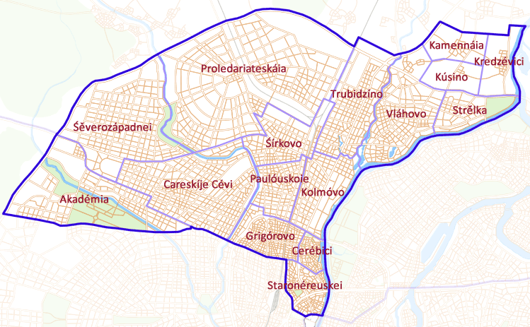
Néreuskei Kónce, to the north of the Krémene, was one of the three original ends. In English it is often rendered "Nerev End" or "Nierev End", named for a Uralic tribe that inhabited in the original settlement.
The end is bounded on the inside by Ólika Kreménnaia (Krémene Street) circling the Krémene, on the outside by the NKD ring road forming most of the city limits (although in the northeast it has extended past the NKD), on the east by the Vołhóve River, and on the south/west by Ólika Legóśtaia (Legóśtaia Street), Ólika Rozváźaia (Rozváźaia Street), Ólika Sołdáteskaia (Soldiers' Street), and Ólika Vodeskáia (Votic Street).
The neighborhood of Staronéreuskei ("Old Nerev") includes the territory of the original medieval Nerev End. However, few buildings from this era survive. Much of it was reorganized and rebuilt in the 18th century, creating parks and several wide avenues in place of chaotic, narrow medieval streets. The mid-20th century again saw much of the region gutted, with large government buildings and offices of many former homes and businesses. The northern section of this neighborhood, though, still includes many older streets and buildings. The most famous location here is the Velíkei Duóre ("Great Square"), site of the Holy Trinity Cathedral.
To the north of Old Nerev are Cerébici and Grigórovo, also frequently considered part of the "old city" since most architecture here is over a century old. Cerébici in particular is known for its great variety of shops and restaurants and its expensive riverside district.
Further out are the neighborhoods of Kolmóvo, Paulóuskoie, Śírkovo, and Careskíje Cévi (literally "The Tsar's Fields", occasionally Anglicized as "Kingsfield"). These regions are more modern and largely residential and business. There are also industrial districts in the northern portions of Careskíje Cévi and Śírkovo and in the eastern portion of Kolmóvo.
The Akadémia (or "Academy") neighborhood in the far west is centered around the Novegradian Academy of the Sciences, a large campus including several colleges, the largest of which is the Institute of the Medical Sciences. Surrounding the Academy proper are mostly residential areas, most of which are occupied by students. The outer end of the district is still largely undeveloped.
The neighborhoods of Śěverozápadnei (or "Northwest") and Proledariateskáia (or "Proletariat") are the most recently developed areas within the NKD. These areas are mostly residential, consisting mostly of freestanding houses rather than the apartments and rowhouses typical of older parts of the city.
Trubidzíno, Vláhovo, and Strě́lka in the northeast are sometimes collectively known as "North Novegráde", as they were independent cities only annexed into Novegráde proper in the 1960s. Like Novegráde these cities were medieval in origin, likely originating in the 14th or 15th centuries. As such they also have very old residential and business centers surrounded by newer developments. Half of Strě́lka is occupied by the western portion of the large Vołhóveskei Sáde ("Vołhóve Garden"); the other half of the park is across the river in Plotníceskei Konéce.
The newest additions to Néreuskei Konéce are the small towns of Kammenáia, Kúsino, and Kredzévici, to the north of Strě́lka and outside the NKD. These neighborhoods still retain a fairly independent feel as they are separated from the rest of Novegráde Velíkei, linked by roads crossing flat, empty fields. The main growth in this area has been in dachas (summer homes) for those who want the feel of a country home but are not willing to part with city services.
Zagródeskei Kónce
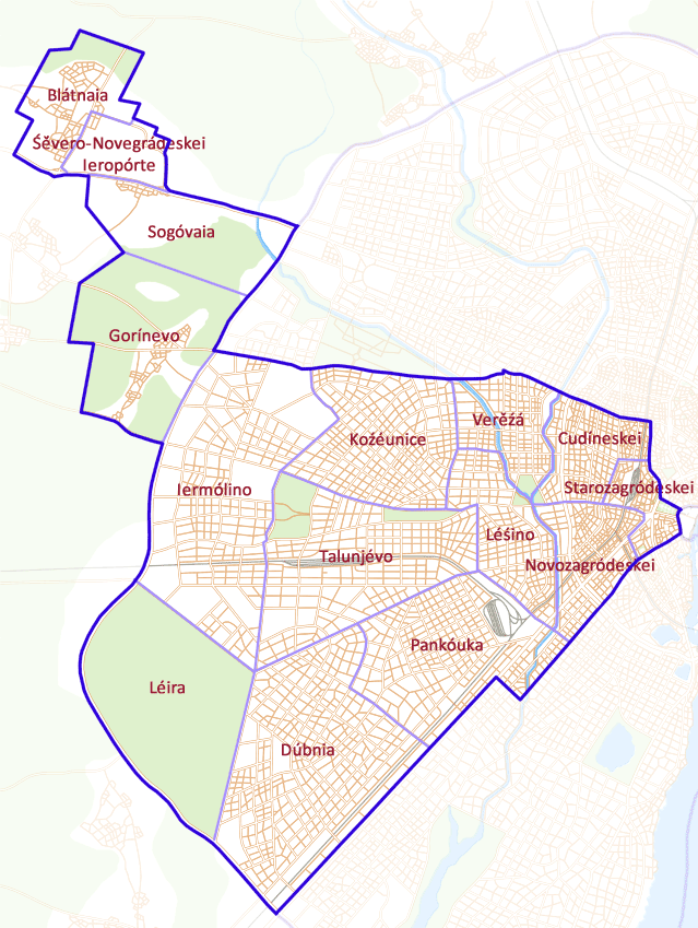
Zagródeskei Kónce, to the west of the Krémene, was the last end to be added to the city. Once the smallest end, it is now the largest. The name originally meant "The End Beyond the Citadel", refering to its position relative to the Krémene. In the modern language, the name instead refers to a less important part of a city (i.e., not the downtown), though not in a pejorative sense. In English it is often rendered "The Suburban End", though this name is technically quite inaccurate.
The end is bounded on the inside by Ólika Kreménnaia (Krémene Street) and on the outside mostly by the NKD, though it has a large arm extending northwest well outside of the NKD. To the north it is bounded by Ólika Legóśtaia (Legóśtaia Street), Ólika Rozváźaia (Rozváźaia Street), Ólika Sołdateskáia (Soldiers' Street), and Ólika Vodeskáia (Votic Street), and to the south by Ólika Prússkaia (Prussian Street), Ólika Barencévaia (Barents Street), and Rubínineskei Próiezde (Rubínine Thoroughfare).
The oldest neighborhood is Starozagródeskei (or "Old Zagródeskei"). It is the site of many government buildings, the famous Párke Pomidí ("Remembrance Park") in front of the Krémene, the State Assembly Building, and Novegráde's Central Railway Station. As with much of the original medieval city, most older buildings have long since been replaced by modern offices.
Novozagródeskei ("New Zagródeskei") and Cudíneskaia are more residential and commercial neighborhoods, originally large boyar manors just outside of the medieval city. To this day Ólika Prússkaia ("Prussian Street") and Ólika Cudincévaia ("Cudincévaia Street") are lined with high-class homes and department stores.
Léśino, Verěźá, Koźéunice, and Pankóuka are all annexed towns that have since become large residential districts, though many public areas and commercial centers are expanding in the former two.
Talunjévo is a smaller business center outside of the Novegradian downtown. It is home to several large parks including the Botanical Gardens and to the city's primary westbound train station, Reveleskáia.
Iermólino and Dúbnia are newer, primarily residential districts. Although they are more built up than the newer developments in other parts of the city, they still have many open spaces. Dúbnia in particular has seen a great amount of recent growth among those who prefer a suburban lifestyle.
Léira (or "The Camp") is a vast forested area, largely uninhabited and without any real administration. It is managed centrally as a public park and forest.
The northwestern arm of the end includes the small towns of Gorínevo, Sogóvaia, and Blátnaia. These towns were annexed in order to bring the Śě́vero-Novegrádeskei Ieropórte (North-Novegráde Airport) under city administration. Most of the territory is still forested and sparsely inhabited, although its proximity to the airport has helped Blátnaia to grow significantly as a stop for those waiting at the airport on layovers.
Ludínei Kónce
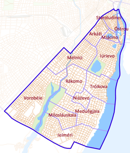
Ludínei Konéce, to the south of the Krémene, was one of the three original ends. In English it is often callled the "People's End" or, historically, the "Commoners' End".
The end is bounded on the inside by Ólika Kreménnaia (Krémene Street) and Ólika Dobrinínaia (Dobrinínaia Street), on the outside by the NKD, Śeloneskáia Dálnica (Śelóni Highway), and Ólika Oreğóvaia (Oreğóvaia Street), on the east by Lake Ielméri and the Vołhóve River, and on the west by Ólika Prússkaia (Prussian Street), Ólika Barencévaia (Barents Street), and Rubínineskei Próiezde (Rubínine Thoroughfare).
Staroludínei ("Old Ludínei") is the oldest settled part of the People's End, though it has been largely rebuilt. The northern part of the neighborhood includes several important government buildings, the largest of which is the Supreme Court of Justice on Ólika Prússkaia. The southern end is mostly commercial and includes several clubs, theatres, restaurants, and hotels. This region is often considered the center of the city's night life.
Óstrou ("The Island") is the city's main international business center. This small island is lined by skyscrapers, the tallest of which is known as the Arctic Tower; at 262 meters and 55 storeys in height, it is the tallest building in the Republic of Novegrad. At the north end of The Island is the Hotel Baltica, the nation's largest hotel.
Arkáźi and Iúrievo were former monastic communities. None of the original monasteries survive, though several associated churches do. These areas have since been developed as mixed-use land, with both small business districts and urban residential districts. Miácino is a small residential/commercial district squeezed in between these two neighborhoods. Much of it is land reclaimed from Lake Miácino, which still occupies a large portion of the Miácino neighborhood.
Most of the other neighborhoods are former towns that have been annexed by Novegrad. Mélnici ("The Mills") is a residential/commercial district formed by the merger of two older settlements, Stáraia Mélnica ("Old Mill") and Nóvaia Mélnica ("New Mill"). Rákomo and the western half of Tróikova are mostly residential, occupied by large apartment blocks. The eastern half of Tróikova, along the shore of Lake Ielméri, is more commercially- and tourist-centered. Niáźevo is a higher class district, known for its mansions, that is believed to have once been owned by the Novegradian Grand Prince. The other four neighborhoods, Meduě́gjaia, Milosláuskaia, Ielméri, and Vorobéie, are largely suburban residential areas.
Plotníceskei Kónce
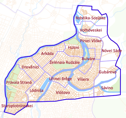
Plotníceskei Kónce, to the northeast of the Krémene, was the fourth end to become part of the city. In English it is frequently called "Carpenters' End", though this meaning has long since been lost in Novegradian.
Plotníceskei Kónce is the only end that does not share a border with the Krémene territory, instead only meeting it at a corner. The outer boundary of the end does not follow any particular road, but instead cuts through forests and fields, occasionally following short local roads. The northern/western boundary is the Vołhóve River, while the southern boundary is formed by a number of roads: Ólika Lubianidzáia (Lubianidzáia Street), Boliśáia Moskéuskaia Drága (Great Moscow Road), Zlátoie Kołcé (the Golden Ring, the inner ring road), and Prospéhte Rogática (Rogática Avenue).
Unlike on the Sophia Side, the "old" districts on the Market Side are not completely dominated by government facilities and many older buildings do survive. In Staroplotníceskei ("Old Plotníceskei"), much of the riverbank had been rebuilt in the 20th century, but only a block away from the river buildings from the 19th century or earlier appear. Parts of the eastern end of Staroplotníceskei, however, have also been rebuilt and are occupied by various businesses or government agencies.
To the north of Staroplotníceskei is the large neighborhood of Právaia Straná (the "Right Side" [of the river]). Právaia Straná is often considered to be the cultural and commercial center of Novegráde Velíkei. The entire western side along the river is parkland. The southern portion of this parkland is home to the Novegráde Velíkei State University, the city's primary university, as well as student housing facilities. The northern portion is a public park, though also includes the Kolizéie ("Colosseum"), the city's largest professional sports arena. The eastern side of the neighborhood includes many restaurants, museums, malls, and department stores, as well as the city Circus and Academy of the Arts.
Lódniśa ("The Wharf") is a heavily industrial area. While transportation by river is no longer as heavily used as it once was, the wharf still sees quite a bit of activity. Many private boaters also use a section of the wharf as a marina.
Drevě́nici and Arkáda are more business-centered districts, with numerous offices and factories. The western portion of Źelénaia Rudzáie is similar, though the rest is not nearly so developed. The center of Źelénaia Rudzáie is a large park, while the far eastern portion is residential.
Hútini, located at the confluence of the Vółhove and Vołhovéke Rivers, was another medieval town absorbed by the growing Novegráde Velíkei in the early 20th century, but unlike other such towns, it still retains a very strong "old European" city feeling, with many crowded, narrow streets and older buildings. The northern portion of Hútini is the eastern half of Vołhóveskei Sáde ("Vołhóve Garden").
The eastern districts of Vlótovo, Lě́tnei Brě́ge ("South Beach"), Víśera, and Pírvei Vlóke, feature a wide variety of developments. Vlótovo and Lě́tnei Brě́ge are mostly residential, though commercial establishments tend to cluster along the major roads. Víśera is a dense residential and commercial district, known for its riverside shops. Pírvei Vlóke along with the eastern portion of Vlótovo are primarily industrial.
The region known simply as Bulváre ("The Boulevard") is known for its main road, the wide Priberéźnei Bulváre ("Riverside Boulevard"), usually just called "The Boulevard". This stretch of road is lined by numerous shops and restaurants, ranging from the easily affordable to the most expensive.
Beyond the NKD are a number of smaller towns: Sávino, Gubárevo, Nóvei Sáde, Vołhóveskei, and Robéika-Sozíjske. These towns have been seeing recent growth as a result of rising tourism and investment in the eastern fringe of Nóvegrade Velíkei, such as in the Bulváre region.
Slavéneskei Kónce
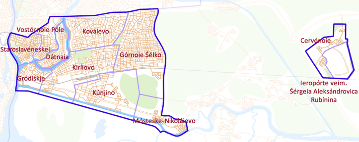
Slavéneskei Kónce (or just "Slavno" in English), to the east of the Krémene, is one of the three original ends. It is the smallest end and the only one to be discontinuous.
It is bounded on the inside by the Vołhóve River and on the outside by the NKD, with a small notch to include the towns of Mósteske and Nikoláievo. Its northern boundary is defined by a number of roads: Ólika Lubianidzáia (Lubianidzáia Street), Boliśáia Moskéuskaia Drága (Great Moscow Road), Zlátoie Kołcé (the Golden Ring, the inner ring road), and Prospéhte Rogática (Rogática Avenue). Its southern boundary runs parallel to the Vołmóste Canal a few kilometers south of the actual canal.
Staroslavéneskei ("Old Slavno") is one of the oldest parts of Novegráde Velíkei proper. On the riverbank is the Iaroslávou Duóre ("Yaroslav Court"), a square dating to the very beginning of the city. The old European markets, known as Gotland Yard and the Peterhof, were once located here as well. Most of the buildings in this district are relatively old, with very little new construction having taken place in the last fifty years.
Vostócnoie Póle ("The Eastern Field") is the more modern extension of Old Slavno. Most of the southern portion is residential, while the northern end is occupied by several industrial complexes.
Dátnaia is an island known for the wealth of most of its residents. As the name suggests, the island was once the site of many dachas, but these have since been replaced by large homes and mansions. The northern half of the island is informally known as Nióli, named for the affluent commune of Neuilly-sur-Seine outside of Paris.
Gródiśkje is probably the oldest established settlement now part of Novegráde Velíkei. It is believed to have been laid by the Scandinavian Varangians on their travels through the area, though the date is unknown. The name of the city, Novegráde (which in the oldest forms of the Novegradian language meant "new fortress"), may be a reference to the original Scandinavian Gródiśkje, which would have been the "old fortress". This area is now heavily developed, with industry being the primary economic activity. The site of the original fortress is protected.
Koválevo and Górnoie Śélko are largely residential regions, becoming more suburban further out from the city. Major roads, however, tend to be lined with more businesses and stores. The northern portion of Kirílovo is similar, though is also known for its large public sports complex and the city's main eastbound train station. The southern portion of Kirílovo, on the other side of the railroad tracks, is not heavily developed.
Kúnjino and Mósteske-Nikoláievo are more recent annexations. Kúnjino is contiguous with the main part of the city, and has seen new growth recently as it is the closest available land to the city center that is still largely undeveloped and has easy access to the rail network. Mósteske-Nikoláievo was primarily annexed because of the completion of the NKD, whose western terminus is in Mósteske. Most of the land between the main city and Mósteske-Nikoláievo is heavily forested.
The non-contiguous portion was annexed to bring the Ieropórte ve jmě́no Śergéia Aleksándrovica Rubínina (Śergéie Aleksándrovice Rubínine Airport) under city control. The small adjacent settlement of Cervénoie was annexed as well, as some airport facilities were located with the town.